Highway asset owners throughout the INFRAVATION partner countries face two major problems with regard to the data needed for maintenance, repair, retrofit and rebuild of their bridges and other structures: a) the extensive time required for data collection by existing assessment methods, and particularly the need for lane closures, given the enormous numbers of bridges in service; and b) the gap between the quality of data available in Bridge Management Systems (BMS) and the information needed for reliable decision-making and subsequent design and construction work.
The need for innovative solutions for rapid and intelligent survey and assessment methods has led to numerous research efforts toward laser scanning and modelling of bridges. However, the models produced do not contain any semantic information. The major remaining problem with these methods is that they require lengthy, expensive and error-prone human efforts to produce object-oriented parametric bridge models (equivalent to Building Information Models, or ‘BIM’ models, of buildings). In the meantime, the transportation service often remains interrupted.
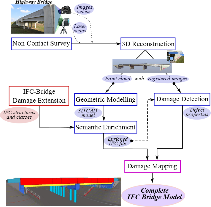
Motivated by these challenges, we propose an automated system that integrates the following novel technical components to provide semantically rich BIM models of bridges:
- Spatial & visual raw data collection with existing rapid and non-contact survey technologies such as laser scanning, video/photogrammetry, etc.
- A bridge object detection and classification software tool for automated compilation of solid 3D geometry from the point cloud data. This includes two steps: a) identification of segment faces and b) compilation of distinct solid objects represented by the faces.
- A rule-processing expert system for semantic enrichment of the solid geometry model to generate a BIM model. This too has two aspects: a) identification and classification of bridge objects (piers, abutments, girders, deck etc.), and b) deduction of supplementary information concerning material types, internal component geometry, etc., based on historical expert knowledge.
- A damage measurement tool for damage identification, classification and spatial/visual properties measurement and integration of this information with the BIM model.
The system concept is illustrated in the Figure bellow: